Perdito en Los Andes
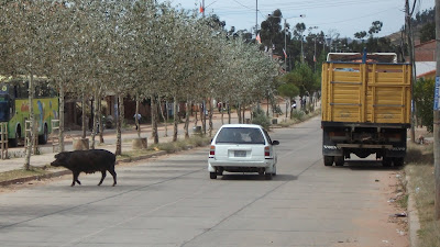
Did I ever mention how easy it is to get lost in Bolivia? No damn street signs, no speaka da Spanish, nobody knows nothing anyway? Getting out of Sucre I knew I had to go south and up. Navigating cities in Bolivia is a three dimensional problem. Your directions are the points of the compass or left and right, plus up and down. This is actually easier than finding your way in a flat city, as the heights give you an overview on where you are supposed to be but ain't, but not much help on how to get there. Part of the problem is that a route is not always obvious, it could look like a bad logging road. Anyway, with much frustration I managed to put myself on the road that would take me from Sucre to the border where I could exitar Bolivia. I took the picture of mama piggy just on the outskirts of Sucre. For the next few days porkers and every other kind of domesticated creature would be a common road hazard whenever I was near farms or towns.
While taking the pig picture, Roger and Jose came up and asked me if they could take MY picture! That was a first for me, so we traded, they got me, and I got them. Jose is the little guy.
After about 60 or so kilometers the Pan American Highway turns into a narrow dirt road clinging to the side of the Andes. Much of it was single lane as well. This is the type of road I imagined I would encounter in South America, just like that top gear episode, but I did not think that it would be the Pan American Highway to Paraguay.
Check out the oncoming traffic in the picture above! Also along the way I encountered a couple from Washington in a full size motor home(!) heading for Paraguay. Their map said this road was paved (mine actually indicated it as dirt, but this was way beyond just an unpaved road). All in all it was a good day as now I was descending into a different eco-zone complete with heat and tropical forest, streams and interesting stuff to look at. When you are averaging 30 kph you see quite a bit.


Comments
Post a Comment